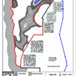
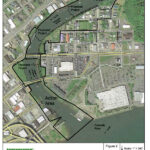
GPS, GIS, GNSS & AutoCAD
EnviroVector utilizes the latest technology to provide the most accurate GPS to GIS mapping. GIS data is incorporated into professional engineering-style AutoCAD drawings that accurately illustrate environmentally regulated features that may affect land use. EnviroVector fully incorporates cartographic field data collected by the best and most powerful Garmin GPS system on the market with the latest ArcGIS technology, producing accurate and high quality mapping data that is integrated into an AutoCAD layer.


Scientific Process
Scientific data is collected in the field using the latest technology. Meters, sensors, charts and numeric data is collected in the field and analyzed using advanced methodology and statistical programs, including SPSS and R Studios. Augers can collect soil samples from 20 feet below the surface, advanced specimen collection provides the most accurate available data, and meters determine groundwater levels. EnviroVector applies the latest and greatest scientific methodology and technology to resolve environmental challenges.